

AllTrails is primarily a travel and fitness app for activities such as hiking, mountain biking, and climbing. It's great at providing information on hikes such as mileage and difficulty but lacks the ability to find campgrounds and access information on those. With more people wanting to go outside, they are also looking for information on how to make their trip more than just a hike. They want to be able to see nearby activities as well.
The intent of this project was to add new features to an app as a challenge to create deliverables that would stay consistent with existing UI and brand guidelines.
To decide what new features might be valuable, I reached out to a few of my friends and acquaintances that enjoy spending time outside hiking, backpacking and camping. From there, I was able to come up with a list of preliminary objectives I want to achieve for this project.
How might we enhance the current user experience for planning a hiking and camping trip with these new features?
To kick off the project, I conducted user research on how people plan their trip specific to hiking and camping trips. I dived into some competitive analysis and market research before moving on to user interviews and surveys.
The goal of my research was to:
People use apps like AllTrails because they want to access information on trail and road conditions. In addition to that, AllTrails also populates nearby trails to provide more options.
I picked the other apps for the competitive analysis because they all have similar features while some actually show nearby campgrounds to more comprehensively help users plan their trip.

It wasn't quite easy to conduct user research in the middle of a pandemic. Nonetheless, I sent out a survey hoping to find people that had experiences using AllTrails.
I wanted to see if I needed to revisit my list of objectives set out prior to beginning the project so the last question I asked was essentially based on that - I gave them a list of features aka objectives and had them pick ones they were most excited about.


The goal of doing user interviews was to dive deeper into the process of how current users plan their hikes and camping trips.
I also based my interview questions on the top features identified in the survey aka the ones that people are most excited about.
From all the insights I gathered from the research phase, I created Jake - a persona that carried common themes across different types of users.

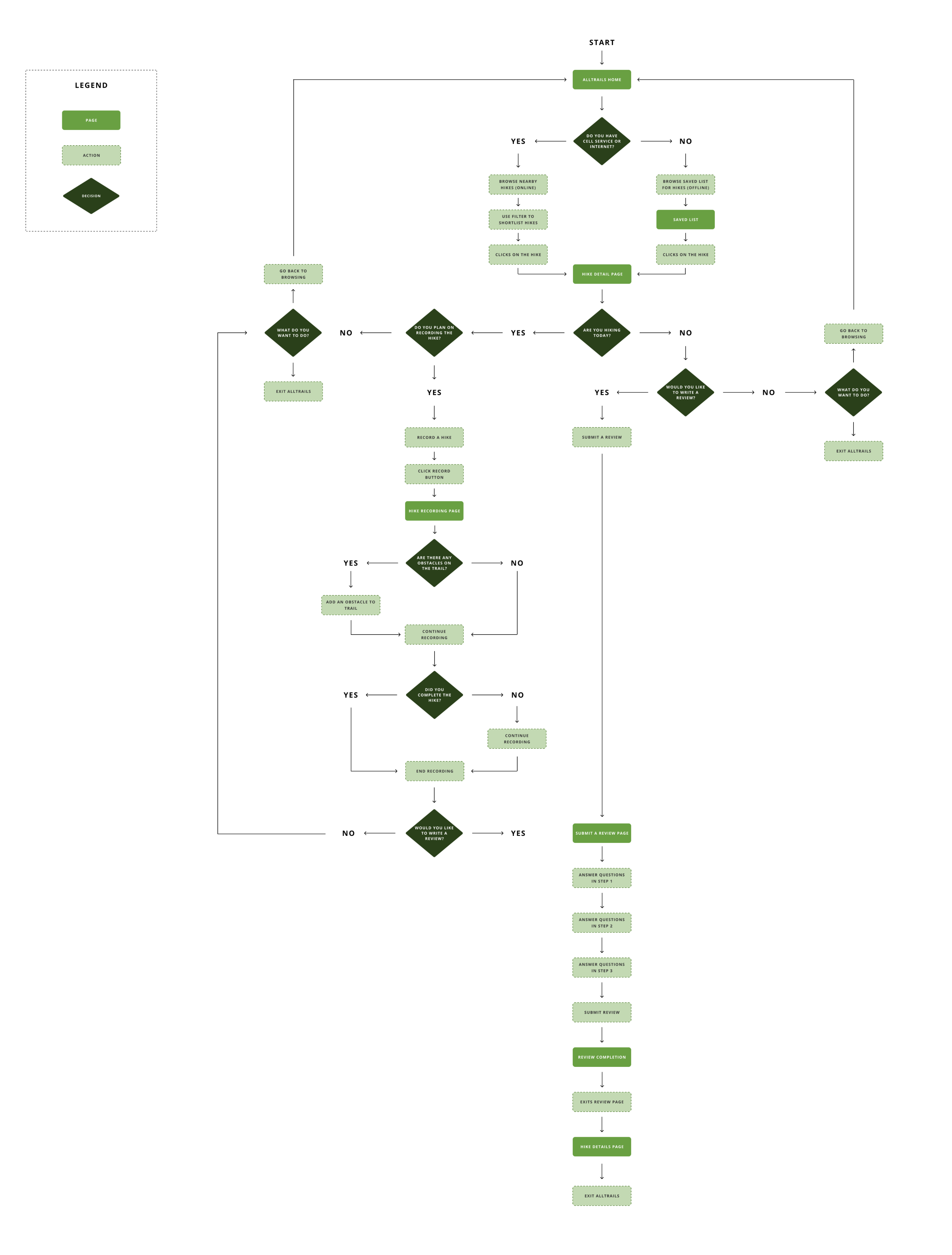
After learning how current users interact with AllTrails in the research phase, I moved on to create a user journey map and user flows where these would not only help me identify some of the missed opportunities the new features could address, but also decide where these new features might locate.
While I had already defined a list of objectives I want to achieve with this project, the user journey map helped identify where these new features can be located.
In addition, it also acted as a point of reference from time to time when I began to map out the user flow.

I created two different user flows that show how users might encounter these new features. The goal was to ensure that whenever we identified a missed opportunity, the new feature would help solve that.
Use the arrows to navigate between the different flows. Click on the image to enlarge.

I felt pretty comfortable with the data I gathered. Of course, there are always opportunities to do more research. However, due to the timeline of this project, I went ahead and started sketching out potential ideas in order to build the prototypes. That way, I could start testing sooner and make adjustments if needed.
I did quick sketches of how I think the features should be built out within AllTrails. I kept all the basics because after all, the goal here is to make the new features obvious enough for users to discover but seamless enough to make it blend into the the rest of the app.
Use the arrows to see the different sketches for various screens.


In the past, I have definitely struggled with testing with only wireframes and not getting the results I wanted. While creating high fidelity prototypes took longer, the results I gathered from user testings were much more beneficial to continue to iterate.


I built the first version of the prototype early because I knew I wanted to do two rounds of testing. I reached out to the people I interviewed during the research phase because they were excited about the features. Unfortunately, I was only able to recruit 5 participants.
I constructed a usability test plan that included relevant tasks specific to each feature plus a couple questions (first impressions and ease of use) that were kept controlled because I was trying to gather the same type of data across each feature I implemented.
The tests were straightforward and I was able to gather just enough data and create an affinity map. I like visualizing feedback through an affinity map because it helps me group similar feedback together and helps me prioritizing changes I need to make if I were to do a second usability test.

I built a second version of the prototype that included the feedback I gathered from user testing. Even though I was constrained to only a small group of people, it still brought me joy to get people excited about these features even though they probably wouldn't be implemented in the real world.
While I didn’t create an affinity map for this, I simply wanted to gather feedback and a gauge on the general feeling of how people feel about the improvements.


...not yet.
This was a really fun project to work on. I chose AllTrails for this project because I personally enjoy going on hikes and camping trips. The idea came about when I was having a conversation with one of my friends about having to use multiple apps just to plan a trip. Of course, I didn't want to base the project on my own biases either so I thought this would be a great opportunity to see what other people have to say as well.
To be frank, a lot of the people I spoke during this project were wondering if I had the intent to reach out to AllTrails about implementing these features. Perhaps one day? But as of December 2022, I know AllTrails have since made it easier to see campgrounds on the maps. That's an improvement.